On this page you will find:
- Access and Recreation Overview
- Right of Way
- Sports, Hobbies and Pastimes
- Key Facts and Figures
- Sustaining the Landscape
- Management Influences and Forces for Change
- Policies for Access and Recreation
Access and Recreation Overview
The Isle of Wight AONB is of great importance to the whole Island community. People value the opportunities available to them for leisure and recreation: from surfing and paragliding along the Tennyson Heritage Coast to taking part in the ‘Walk the Wight’ annual cross-Island sponsored walk. Whilst only a small proportion of the population live within the designated area, there are numerous settlements that are immediately adjacent to the AONB. Bearing in mind the dispersed nature of the AONB, access to these special landscapes is a relatively short distance, even from the most built-up urban areas on the Isle of Wight; sometimes, just a short walk.

The Countryside Code116 (Respect, Protect and Enjoy) provides guidance on the way we can all explore the countryside in a considerate and sustainable way. It says:
Respect other people
- Consider the local community and other people enjoying the outdoors.
- Leave gates and property as you find them, and follow paths unless wider access is available.
Protect the natural environment
- Keep dogs under effective control,
- Leave no trace of your visit and take your litter home
Enjoy the outdoors
- Plan ahead and be prepared
- Follow advice and local signs.
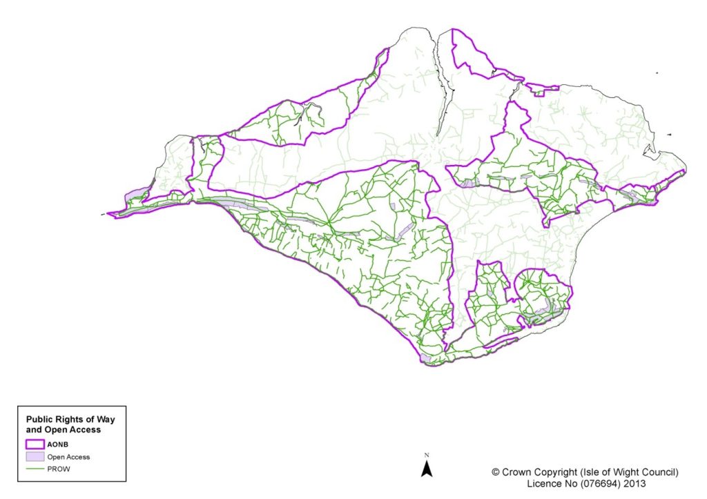
Right of Way
Rights of Way are an essential means of sustainable access to the Isle of Wight AONB landscape and the extensive Rights of Way network provides a protected and managed public resource. The category of Public Right of Way dictates the right of access from footpaths, bridleways and byways to areas of Open Access land.
Many of the Isle of Wight AONB’s public paths are a historic record of how people have travelled across the landscape: from villages to the coast; from farms to the downs and the markets of nearby towns; and from hamlets to churches and schools. Their social importance is reflected in many of them being named (Dark Lane, Hoxall Lane, Rowdown Lane, etc). Much of the road network would have originally been of a similar character to these routeways, as described in the ‘Historic Routeways HEAP’.56
The Countryside and Rights of Way Act 20005 brought in a statutory definition of a new public right to access on foot to open countryside. Over 1000 ha of ‘Open Access’ are in the designated landscape including extensive areas of the Isle of Wight AONB downland and woodland, much of which was already publicly accessible through ownership of organisations such as the National Trust and Forestry Commission. It is anticipated that there will be an increase in Open Access land when the King Charles III England Coastal Path National Trail is confirmed. Under the Marine and Coastal Access Act 200937 generally all land on the seaward side of the National Trail will be classified as Open Access.
A number of promoted routes traverse the landscape linking Isle of Wight AONB with the adjacent rural villages, towns and urban centres of the Island (e.g. Worsley Trail, Tennyson Trail etc).
Natural England, under their obligation to establish a coastal path along the English coastline (the King Charles III Coastal Path), is actively working with landowners and the local authority to provide a National Trail along the Island’s coast. Whilst much of the route is already established, there are parts of the coast which are exempt or not included in the proposed Trail, such as the east of the Newtown estuary and Osborne coast which are in the Isle of Wight AONB.
In 2018 the Isle of Wight Council produced its second iteration of its Rights of Way Improvement Plan117 to cover the period 2018-2028. The following policies are established:
- Policy A: Maintain a high quality right of way network
- Policy B: Making improvements to the existing network
- Policy C: Create new access
- Policy D: Promotion
Sports, Hobbies and Pastimes
In addition to the cultural benefits of activities within the Isle of Wight AONB; the patchwork farmland, downs, hills, woodlands, coasts and estuaries are the location for many sports and recreational activities such as walking, cycling, horse riding, paragliding, shooting, sailing, surfing, windsurfing, kitesurfing, snorkelling and fishing. The Isle of Wight AONB also provides the backdrop and space for sport and outdoor events including: The Round the Island Race, Cowes Week sailing regatta and the annual Spring and Autumn Walking Festivals featuring ‘Walk the Wight’. There are so many ways the landscape can be explored and enjoyed.
Some of these activities on their own have a limited landscape impact, but cumulatively, or if under taken in large enough numbers may be problematic. For this topic, we have focused on those activities which have the greatest potential to influence the landscape character of the Isle of Wight AONB.
Keeping of Horses
Historically horses were used to farm the landscape or as a means of transport. Increased mechanisation, particularly changing farming practices in the 20th Century led to a decrease in the number of horses actively used in farming. Increased affluence and leisure time from the 1960s onwards saw a number of farms diversifying into riding schools and then providing livery. From the 1970s individual horse ownership started to increase, initially with the horses being kept on the farm livery sites, but since the 1990s there has been growth of small paddock ownership by those who keep horses. This was helped by farms selling parcels of land; initially pasture, to help supplement the declining profitability of dairy farming. With increasing demand, paddock now commands a higher price than most types of farmland and this has led to the keeping of horses being a feature in the AONB landscape, particularly, but not confined to Traditional Enclosed Pasture areas.
Change of use towards recreational pursuits such as keeping horses has the potential to radically change the character of the landscape and if unsympathetic can cause significant harm to the conservation and enhancement of the AONB. Conversely, if managed in a way which is appropriate to the landscape character, horses have the ability to continue to provide the grazing needed to prevent scrub growth and keep grasslands in a good state of management. Often the keeping of horses requires additional fencing, shelters, jumps, stabling, feed storage, sand schools, manure storage and disposal and other such paraphernalia. All of these can have a negative impact on the landscape.
There is a need for the Isle of Wight AONB to work with equestrian organisations to develop guidance on keeping horses in the protected landscape.
Shooting
There are approximately 50 shoots on the Island ranging from larger commercial operations to small scale and local recreational activities. They contribute to the rural economy and can have environmental benefits. The game shoots operate in the pheasant and partridge seasons between September and the beginning of February. Pheasants are brought to the Island to supplement birds reared locally to provide sufficient stock the shoots. Game cover has been provided through management of existing woodland, or additional woodland planting for this purpose. In addition game crops, such as maize, kale or quinoa are planted to provide habitats and cover. Management of land for shooting has the potential to radically change the character of the landscape. If landscape character appropriate, it can contribute to woodland wildlife and landscape objectives. However, there is the potential for inappropriate approaches which can cause harm by significantly altering the landscape character.
The Isle of Wight AONB needs to continue to engage with the landowning community regarding both the positive and negative aspects to shooting.
Fishing
Small fishing boats operate from Yarmouth and several other smaller coves and bays around the coastline of the Isle of Wight AONB. Beach fishing, coarse fishing and sea fishing are all enjoyed with a number of coarse fishing ponds and chartered boats operating in the area.
There are fishing lakes at Nettlecombe, Thorncross and Combley which are run for members or as part of a holiday experience.
Due to the diverse nature of the angling sector on the Island, we have little in the way of detailed information regarding commercial or recreational fishing activities in the Isle of Wight AONB or the impact or benefits they bring to the area.
Health
The Isle of Wight Joint Strategic Needs Assessment was updated in 2022 in their ‘Isle of Wight Healthy People’ report118.
Amongst many challenges facing the community of the Island, living longer with chronic medical conditions, deteriorating mental health, obesity and finding the funding to secure these services are the most acute. Access to landscape and nature can improve both mental and physical health and the Isle of Wight AONB, amongst other places of natural beauty, can provide the opportunity for residents and visitors to experience real health benefits.
The Isle of Wight has a statistically higher prevalence of mental illness than the English national average. The percentage of people diagnosed with a mental health problem and on a GP register is approximately 10.1%, this equates to 14,200 people. The prevalence of severe mental illness is higher than the national average with 1,730 people (1.19%) as opposed to a national average of 0.95%. The rate of GP registered people with diagnosed depression is around 11.7%
Key Facts and Figures
Sustaining the Landscape
The natural environment is important to human health not just for the physical ‘work out’ that can be enjoyed through walking, cycling or other countryside pursuits, but also for positive benefits it has on mental health and a sense of wellbeing. Being able to easily access the countryside is increasingly being seen as of key importance in raising health levels and going some way to resolving obesity issues. As well as the installation of a network of green infrastructure within and around settlements, there is a need to ensure that there are good connections with the existing rights of way network to allow for more easy access into the AONB countryside.
Linear public Rights of Way can restrict the impact upon sensitive sites valued for their wildlife, historic and geological importance. Conversely intensive use of linear routes can cause significant harm to these same features. The Isle of Wight National Landscape Partnership would like to understand more about recreational impacts on vulnerable and ‘honey pot’ sites.
Events such as the guided walks of the spring (May) and autumn (October) Walking Festivals provide the opportunity for residents and visitors to learn more about the protected landscape and Heritage Coasts and gain further enjoyment though insight into our history and environment.
There are approximately 2000 horses and ponies in work on the Isle of Wight with a total population of just over 3000. There is a significant and noticeable equine presence on the Isle of Wight, which contributes to the Island’s economy and impacts rural life.
Management Influences and Forces for Change
DEFRA have produced Protected Landscapes Targets and Outcomes Framework15 which includes a requirement for Isle of Wight National Landscape Partnership to improve and promote accessibility to and engagement with the designated landscape.
The highways network includes roads, cycleways and Public Rights of Ways. The Isle of Wight Council, as Highway Authority, is responsible for the maintenance, protection and management of the network. The Private Finance Initiative (PFI) transferring the maintenance of cycleways and roads to Island Roads has meant that Rights of Way are now managed separately from the rest of the highway network. To maintain effective sustainable access to the Isle of Wight AONB, there is a need to ensure that integration between all parts of the highways network continues.
The Isle of Wight Council Rights of Way department administers the Isle of Wight Local Access Forum119 which meets quarterly to discuss highways and other rights of way issues. Local Access Forums (LAFs) are statutorily prescribed bodies, introduced by sections 94 and 95 of the Countryside and Rights of Way (CROW) Act 20004. Their main function is to advise the Isle of Wight Council, as to the improvement of public access to land in that area for the purposes of open-air recreation and enjoyment. The Forum is made up of local interest groups and individual members and is attended by parish and town council representatives.
The Rights of Way Improvement Plan 2018117 forms part of the Local Transport Plan and sets out a number of policies and potential projects to improve walking, cycling and riding opportunities across the Island to 2028. These include:
- Maintaining a high quality rights of way network
- Make improvements to the existing network – working with Town and Parish Councils and developers
- Creating new access – disabled access and community links
- Promotion – for sustainable journeys, health and leisure
Local Walking and Cycling Infrastructure Plans, which help communities identify priorities for funding of local walking and cycling infrastructure, have been developed progressively since the publication of Newport and Ryde Plans in 2018. Further plans were prepared in 2022 for
- Cowes, Northwood and Gurnard
- East Cowes and Whippingham
- Bembridge, Brading and St Helens
An LCWIP was adopted for the Bay area in 2024.
Cyclewight have produced ‘A cycling strategy for the Isle of Wight’120 ‘to make the Isle of Wight a place where people of all ages and abilities feel able to cycle safely and easily and enjoy the experience’. The Strategy includes improving links at Freshwater, Godshill and Alverstone in the Isle of Wight AONB.
As part of a successful award from central Government around Levelling Up the Isle of Wight Council will receive £ 13.6m for a number of ambitious projects. These include:
- Ryde to Yarmouth Public Transport Corridor – around bus infrastructure
- West Wight Greenway – cycleway from Gunville to Freshwater
- Newport Hub and Spokes Scheme – improve Newport for walkers and cyclists
The Motoring Organisations’ Land Access and Recreation Association (LARA) have published ‘Managing Motor Vehicle Use in the Countryside’ guidelines on managing motor vehicles on unsurfaced (unsealed) public roads 121
Promotion of access to the countryside needs to go hand in hand with an assessment of the impact of recreation and leisure activities on the landscape and special characteristics of the Isle of Wight AONB.
The economic viability of farming and forestry has a direct link to the pressure for the subdivision and sale of land for non-agricultural or woodland management use. This increases the pressure for alternate uses for recreation and leisure activities which in some cases may have potential to impact on the character of the landscape.
In October 2023, Defra announced that it had reversed its earlier decision to repeal the rights of way ‘cut-off date’ legislation and that the cut-off date would be implemented, but deferred five years, from 2026 to 2031. This legislation will extinguish any historical rights of way not recorded on the definitive map by the cut-off date.
Policies and Priorities for Access and Recreation
These policies should be read in conjunction with the overarching objectives for the Isle of Wight AONB as detailed on the welcome and overview page – Isle of Wight National Landscape: Area of Outstanding Natural Beauty Management Plan 2025-2030 – Isle of Wight National Landscape.
P53 Promote and celebrate the AONB as a venue for sustainable recreation where this does not conflict with the purposes of the designation.
P54 Encourage responsible use of the existing public rights of way and open access areas across the Isle of Wight AONB which provide access to its diverse and beautiful landscape.
P55 Encourage the development of educational and health activities, with both delivery organisations and participants, in the designated landscape, to better understand the relationship between their activities and the Isle of Wight AONB objectives.
Priorities for Delivery
- Promote guidance to access and recreational users of the AONB for them to have better understanding of their impact on the landscape on the newly established King Charles III England Coast Path National Trail.
- Promote increased accessibility to the designated landscape for less abled, minority and deprived communities and fulfil the requirements of the DEFRA Protected Landscapes Targets and Outcomes Framework.
- Encourage AONB access for recreational and educational activities that improve skills, confidence and health and well-being.