On this page you will find:
- Historic Environment Overview
- Key Facts and Figures
- Sustaining the Landscape
- Management Influences and Forces for Change
- Policies and Priorities
Historic Environment Overview
The complexity of the landscape within the Isle of Wight AONB is a legacy of the centuries-old intricate relationship between people and place. Closely linked with geology, the historic environment is defined by Historic England and the NPPF as:
“All aspects of the environment resulting from the interaction between people and places through time, including all surviving physical remains of past human activity, whether visible, buried or submerged, and landscaped and planted or managed flora51.”
And so, comprises: archaeology, the built environment and the historic landscape.
It is essential that the importance of this resource is understood if we are to conserve and enhance the AONB.

The historic environment is a major contributor to the landscape character of the Isle of Wight AONB. Set out below are some of the most significant features, from a landscape perspective but this is by no means an exhaustive list.
- Open downland and heathland dating back to the woodland clearance of these areas from the Neolithic and in particular the Bronze Age and Iron Age periods.
- Human management of semi-natural woodland over several millennia and the creation of plantation woodland in the recent past
- Spring-line settlement and other settlement patterns directly related to landscape and landform, highlighting how people took advantage of sources of fresh water, shelter from prevailing winds and/or were linked with the local church and manor.
- Vernacular architecture embracing various traditional styles and reflecting the Island’s complex geology and locally available materials. Walls may be constructed of various types of greensands, Bembridge limestone, chalk or locally made bricks while roofs are typically slate or thatch.
- Ceremonial sites such as The Longstone at Mottistone, burial mounds on chalk downland and sandstone hills, and structures such as churches and religious houses
- The historic enclosure of downland, heathland, open farmland, common and waste which took place in a piecemeal fashion over a long period of time particularly from the Tudor period into the eighteenth and nineteenth centuries. Closely associated with
- Historic boundary features such as hedgerows, ditches, hedge banks, wood banks, and stone walls and associated field patterns. Many earthworks were used to demarcate boundaries relating to medieval parishes, manors and other land holdings and can still be seen in the landscape of the Isle of Wight AONB today.
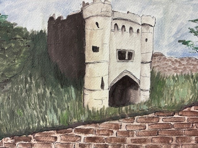
- Features and sites associated with safety and defence such as beacon sites, lighthouses, castles, forts and World War II and Cold War structures.
- Roman Villa sites, medieval planned towns, Tudor and Jacobean manors and farmsteads.
- Highways, byways, paths, and tracks many of which are now part of the road or public rights of way network.
- Industrial archaeology sites from quarries, old salterns, brickworks through to rocket testing.
- Marine sites such as protected wrecks and submerged landscapes.
- Designed parkland landscapes and ornamental gardens associated with grand houses such as Appuldurcombe, Northcourt, Nunwell, Norris Castle and Osborne.
- The identification of the Isle of Wight and parts of what is now AONB as a place to visit as part of the English Grand Tour and the ‘Picturesque’ movement.
- Royal patronage and the Royal Palace at Osborne House
- The increasing popularity of the Isle of Wight AONB as a place to visit or to move to during the nineteenth and the twentieth centuries and the associated changes to settlements and facilities at sites which became attractions.
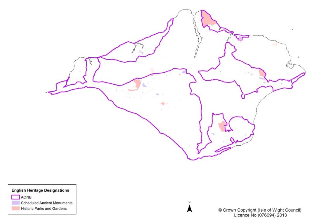
Key Facts and Figures
- 19 Grade I listed Buildings
- 33 Grade II* listed Buildings
- 608 Grade II listed Buildings
- 111 Scheduled Monuments
- 9 registered historic parks and gardens on the National Heritage List for England either partially or wholly within Wight AONB plus 12 historic parks and gardens on the Local Heritage List within Wight AONB.
- 23 Conservation areas, partially or wholly in the AONB.
- 6490 sites in the AONB on the Historic Environment Record
- 36 Local Heritage List (built structures) in Isle of Wight AONB.
The Heritage at Risk Register 202352 has highlighted 10 sites within Isle of Wight AONB at risk and comprises a range of heritage assets i.e. 4 Scheduled Monuments; 4 Listed Buildings; 2 Registered Parks & Gardens.
Sustaining the Landscape
The Historic Environment provides a finite resource of evidence for past human activity. Through this we can better understand the origins of the Isle of Wight AONB landscape and the relationship between people and places. Additionally, through investigation of palaeo-environmental evidence e.g. pollen record we get a better understanding of how climate and land use has changed over time. This can be used to better inform current choices of land management.

The intricate relationship between people and place throughout time is visible in the historic environment contributing to academic knowledge but also giving people a link to the past, engendering a sense of belonging and providing a practical educational resource.
The Isle of Wight AONB holds some of the finest archaeological sites, historic landscapes, buildings, and structures on the Island, many are designated and protected heritage assets. There are also many non-designated heritage assets that positively contribute to the historic environment. Many of these are recorded on the Historic Environment record although new assets / sites may be identified and afforded weight during consideration of a planning application by the local planning authority.
These resources are finite and need careful consideration, management and in some cases protection.
Management Influences and Forces for Change
National Guidance
Historic England is the national body which oversees matters relating to the Historic Environment in England. It provides guidance on the best way to achieve national policy objectives for the Historic Environment to a range of stakeholders. A current list of information is available on the Historic England website and includes:
- Conservation Principles, Policies & Guidance for Sustainable Management of the Historic Environment (English Heritage 2008)
- Understanding Place; Historic Area Assessments. (Historic England April 2017)
- Heritage at Risk in 2023 – current web-based national evidence base.
- Good Practice Advice (GPAs) and Historic England Advice Notes (HEANs) [https://historicengland.org.uk/advice/planning/planning-system/]
Policies and legislation affecting the historic environment
The National Planning Policy Framework10 and the draft Island Planning Strategy22 contain policies that enable the local planning authority to manage change to all heritage assets, including non-designated heritage assets, in a manner commensurate with their significance and contribution to the historic environment. A heritage asset is defined in the National Planning Policy framework as ‘a building, monument, site, place area or landscape identified as having a degree of significance meriting considerations in planning decisions because of its heritage interest’ (NPPF 2023, Glossary, p.70).
The Planning (Listed Buildings and Conservation Areas) Act 199053 (as amended) and Ancient Monuments and Archaeological Areas Act 197954 (as amended) legislate over works to Listed Buildings, Conservation Areas, and Scheduled Monuments and amongst other things illustrate duties and powers of the Local Planning Authority in this regard.
DEFRA’s Protected Landscape Targets and Outcomes Framework requires Isle of Wight National Landscape Partnership to decrease the number of nationally designated heritage at risk in the designated landscape.
Historic Environment Record
The Isle of Wight Historic Environment Record (HER), maintained by the Isle of Wight Council Archaeology and Historic Environment Service (IWCAHES), comprises a computerised database linked to a Geographic Information System (GIS), complemented by documentary archives, historic maps, aerial photographs, and an archaeological library.
The HER is continuously updated as a result of fieldwork including excavations, geo-physical surveys, research and other projects by commercial and voluntary organisations and individuals. It contains detailed information on archaeological monuments; find spots (including those from the Portable Antiquities Scheme); historic buildings and structures; coastal, maritime, military, and industrial sites; parks and gardens; and landscape features.
The Isle of Wight AONB Partnership utilises the HER to obtain an accurate picture of the historic environment and its needs.
Historic Landscape Character
The Historic Landscape Character (HLC) programme, promoted by Historic England, is a methodology to describe the cultural, historic, and archaeological features contributing to the time-depth and character of the landscape. Time-depth is the visible evidence in the present-day landscape for change and continuity over long periods of time.
The Isle of Wight HLC was prepared by the Isle of Wight Council Archaeology and Historic Environment Service (IWCAHES) between 2002 and 2006 with the support of English Heritage and the Isle of Wight National Landscape Partnership.55 The HLC forms a record and analysis of the landscape at a specific point in time.
The HLC forms an integral part of the HER as a layer within the HER GIS and a dataset within the HER database alongside monument, event, source, and consultation records. It is maintained by IWCAHES. This identifies historic landscape types such as field patterns, woodland and settlement and divided the Island into HLC Areas. It led to the development of a series of Historic Environment Action Plans (HEAP)53 between 2008 and 2015. These plans relate to individual HLC Areas (discrete parts of the Island with their own distinctive character) and HLC Types (such as settlement, routeways, field patterns, military sites, parks, and gardens etc). The Rural Settlements and Rural Buildings HEAP describes the varied character of settlements and the built character of these settlements which contribute significantly to the landscape of the Isle of Wight AONB
Isle of Wight Cultural Strategy
In June 2023 the Isle of Wight Council adopted ‘All the Wonder’ the latest Isle of Wight Cultural Strategy57. The Strategy, vision is that ‘by 2033, the Isle of Wight will be recognised as a place that celebrates its rich cultural heritage and the creativity that shapes everyone’s individual and community prosperity’.
Other Factors
Land use practices have the potential to help to conserve buried archaeological remains or to significantly increase damage to this finite resource through the impact of stock erosion or arable ploughing.
Changes to weather patterns and general climate may result in increased erosion and weathering of sites and historic structures. Fluctuations in the water table and the drying out of peat deposits have implications for the palaeo-environmental record and wetland archaeology. Increased storms, mitigation for flood risk, conservation projects and rates of coastal erosion may lead to more frequent exposure of buried sites along undefended coastlines and increased risk of damage to historic built structures (even where there may be coastal defence).
Development and other activities, including climate change adaptation and mitigation projects, have the potential to damage buried archaeological and palaeoenvironmental features. It is important that archaeology is raised as an issue during the process of assessing development proposals and that mitigation and recording is recommended where appropriate. Making archaeological assessments available to the public can raise awareness of the importance of recording archaeology as a part of the development process.
The Portable Antiquities Scheme has encouraged the recording of finds but there may still be incidences of unreported finds which may prevent us from having a better understanding of past peoples in the landscape.
Policies for Historic Environment
These policies should be read in conjunction with the overarching objectives for the Isle of Wight AONB as detailed on the welcome and overview page – Isle of Wight National Landscape: Area of Outstanding Natural Beauty Management Plan 2025-2030 – Isle of Wight National Landscape.
P9 Support measures for the on-going conservation of this finite resource such as appropriate farming, forestry, other land use (such as building development), and maritime activities, to ensure the Isle of Wight AONB and DEFRA Protected Landscapes Targets and Outcomes historic environment objectives are met.
P10 Support the positive management of change to designated and non-designated heritage assets during the consideration of planning applications affecting the Historic Environment
P11 Encourage opportunities to prevent the decline and improve the management, monitoring and maintenance of heritage assets identified within the Isle of Wight AONB.
P12 Encourage opportunities for responsible access and enjoyment of the historic environment of the Isle of Wight AONB and promote and celebrate the importance of the historic environment of the AONB.
P13 Monitor the impact of forces for change (such as recreational activities, development, land use and climate change) on the historic environment of Isle of Wight AONB.
Priorities for Delivery
- Promote the recording, understanding, conservation, enhancement, and interpretation of the historic environment in the Isle of Wight AONB.
- Encourage educational activities that raise awareness of the historic environment and promote access to heritage sites in the Isle of Wight AONB
- Support finding viable uses for historic buildings and sites to help secure their future survival.